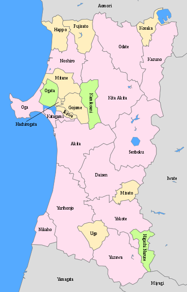
From Rokugo we headed north following the Nairiku train line to Kakunodate, Ani and Takanosu. The amalgamation of local governments makes the area increasingly difficult and frustrating to navigate. When local governments merge, former names gradually disappear from use with the exception of railway station names. Sometimes, as in the case of Odate big cities enroach on towns and villages that no longer have the numbers or the economies of scale to remain independent. In other cases towns merge with a generic all encompassing name like "Kita Akita city" which has replaced Takanosu, Ani and Akikawa towns. From Odate the signs to Kita Akita shi are pretty meaningless - almost anywhere south will be somewhere in Kita Akita shi.... But the scenery is lovely - much better than late April when we once took the Nairiku sen north from Kakunodate.
 |
| A map of increasingly generic sounding places - I can't work out why Misato is considered Senboku district though it doesn't border it. |
 |
| Pretty scenery that would be prettier without the pesky electricity lines. |
 |
| Butter mochi at the Ani Michi no eki - I resisted temptation here but succumbed later in Odate - very sweet but delicious! I haven't seen them before - a new regional specialty? |


2 comments:
There's a Yuzawa, too! :)
Yes! It can be a bit confusing.
At least the name Yuzawa in Akita wasn't the result of amalgamation - probably both have hot water streams :)
I don't understand why places choose obviously bland names, or why it's necessary to do away with the town names as part of amalgamation... bland out.
Shinjuku ku is more interesting than most kus in Tokyo in terms of names - they've managed to keep the machi names much better than other areas - Ginza 1-9, Iriya 1-9, Akasaka 1-9.... so many place names and so much history have been wiped out... :(
Post a Comment