 From Kitakami, the plan was to go north west to lake Tazawa on mountain roads. (The map here has Kitakami marked, Tazawa is west of Morioka, east of Akita city). On the way we passed numerous dams. Even though only 8% or so of Japan's energy consumption comes from hydro power, dams seem to take a disproportionally large part of Tohoku, that said though, many of them are quite pretty.
A dam NW of Kitakami, alongside the Kitakami train line which runs between Kitakami and Yokote in Akita. It's peak snow melting season and water levels are extremely high. Many trees are partially submerged in the photo above.
A river whose flow has been curbed by a dam
Snow in the mountains yet to melt
Signs of spring
Mountain roads....
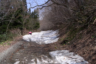
Mountain road - snow ahead - an abandoned snowmobile.
Snow covered mountain road... impossible to traverse - we turned back and followed a more major road to Tazawako.
http://www.welt-atlas.de/datenbank/karte.php?reg=&kat=&kartenid=6-390 (reference for the map)


No comments:
Post a Comment